One of the problems with ocean chemistry was that oceanographers were trying to solve the great salinity mystery. And what was that?
Oceanographers had known for a long time that the salt concentration of the oceans could be accounted for by rivers dissolving salt and depositing it in the seas where it concentrates. At the rate of salt deposition by rivers, the oceans were about 80-90 million years old. This had been known since the late 19th century.
And in fact there was another factor. There is an old Norse myth that the reason the oceans are salty is that there is a giant salt mill under the sea, forever churning away. The Norse were not far wrong---the spreading centers at the mid-ocean ridges are continuously putting more salt in the sea. We've all seen those hydrothermal vents---they are full of salt dissolved very efficiently from the hot rocks they percolate through. So the actual time it takes to achieve today's ocean salinity is only 60 million years.
This age for the oceans was supported by
Lord Kelvin, who believed that the sun was not much more than 100 million years old, and probably less.
The young salt oceans were used to support evolution (our blood is about 0.8% salt, and it was supposed that this was the salinity of the ocean when our amphibian ancestors left the sea, with that concentration 'preserved' in our bodies till this day (I read this in my 10th grade biology book as well) It was also used to attack evolution because Charles Darwin thought the world had to be several billion years old.
Geological evidence by the 1920s with radioactive decay of uranium into lead proved that the world was over 2 billion years old. The question immediately became, why aren't the oceans more salty?
Equilibrium had long been recognized as the oceans being 15% salt. That's what the salinity would be if there was no way to remove salt from the oceans. That clearly hadn't happened. And had never happened.
Our cells, animal, fish, plant, cannot tolerate that much salt. Of course a 2% salt concentration would kill us very quickly through osmotic dessication. But even if the concentration is even between cell walls and their surrounding fluid, at 5% the 'pulls' of the sodium and chlorine ions dissolved in the water will pull apart the phospholipids that make up the cell membrane.
Yes, there are freaky organisms like brine shrimp that are able to keep salt out of their bodies (their internal salt concentration is the same as ours) Life is still possible with salinity over 5%, but all higher forms of life would go extinct faced with such salinity (aside from oddballs like brine shrimp) and the forms of life would have been very different even if salinity had reached 5%--and such life forms are rarely observed in the fossil record. Also, marine organisms that would have gone extinct if salinity
had risen above 5% have not.
This drove oceanographers to distraction. How the hell do oceans get rid of their salt? Salt spray carrying salt back to the land was out. Except for hurricanes, salt spray does not go far inland, and any salt deposited on shore a few yards away washes back in with the next rain. And analysis of rainwater shows that salt is present in the most miniscule amounts.
It has been recognized that salt can be removed through evaporite deposits and covered with sediment that prevents it redissolving into the sea. When the Mediterranean dried up several times 5-6 million years ago each occurrence removed trillions of tons of salt that were covered by river and wind-borne sediments. Salt domes form in similar circumstances, through evaporation from restricted marine basins and burial under sediment.
That was worked out gradually in the 1960s and 1970s, but there is still a nagging problem. That can account for the salinity of the oceans staying well below 5%, but it seems a bit weak to most. After all, what happens if due to some continental configuration, there just aren't any restricted marine basins (or enough of them) to form enough salt deposits to keep ocean salinity down? This salt deposition process can account for the average salinity of the oceans, but with varying continental configurations there would be large and lethal salt variations.
Another mechanism for salt removal is the subduction of oceanic crust, impregnated with salt water in every pore---steam is released in volcanoes, but not much salt (usually---there are a few volcanoes along subduction zones that have very salty magma)
Proponents of
GAIA theory propose that ocean salinity is under biological control. They propose two main mechanisms---salt being captured/incorporated into diatom and coccolith shells as they drift to the ocean floor after the animals die. The higher the salinity, the more salt they would capture. This hypothesis was tossed around a lot in the 1970s, but has since been found wanting. Diatoms do not capture more salt in their shells when salinity rises---and at much above 4.5% salinity they die.
The other is that reef building organisms help create restricted basins that trap salt deposits under sediments and marine skeletons. This does have some backing to it--coral atolls do trap layers of salt in lagoons and bury it under coral skeletons, and the Great Barrier Reef could certainly trap many billions of tons of salt.
But even this hypothesis seems weak. Reef building organisms have existed for several hundred million years, with different types of organisms forming them in different periods. But the oceans formed more than 4 billion years ago. So reef-building organisms cannot account for the stability of the salinity of the oceans for over 3 billion years. (Yes there were
stromatolites 3 billion years ago. And they do trap salt, to a degree. Quite avidly, actually. But they live in tidal zones, and not in shallow marine seas, where they could trap salt on a much larger scale. Stromatolites simply can't trap enough salt to keep the salinity stable)
There are some negative feedbacks that help stabilize the salinity of the oceans in the absence of biological control. During the time of
Pangaea, all the continents were together, and there were no marginal, enclosed seas, or very few compared to today (The Gulf of Mexico, the Red Sea, the Mediterranean Sea, the Persian Gulf, the Caspian Sea, among other examples). But computer modeling and geologic evidence also shows that most of Pangaea was very arid--far away from the oceans and their moisture bearing winds. Much like the interior of Asia, only more so. And large endorheic basins trapped salt carried by what rivers there were in evaporite deposits in the interior of continents. (although these could get washed out later when exposed to rainfall when the continents separated)
So, supercontinent---not many marginal seas to form evaporite deposits, but not much salt transport from the land. Continents scattered about--more rainfall on land but more marginal/partially enclosed seas to trap salt.
But it's still hard to see how there wouldn't be salinity crises occasionally. Until recently, we didn't even know how continents assembled and broke apart very well before Pangaea. But over the last 15 years there has been a revolution in paleocontinent studies---through careful exploration and analysis of isotopes in rocks, geologists believe that they have identified all the prior supercontinents!
It has to be said that supercontinents have been increasing in size as
continental crust increases with time. Before Vallbara, there is no evidence for continents at all. Earth seems to have removed its heat through
hot spots. 4 billion years ago, if we had seen the Earth we would have seen a planet-wide ocean, probably less than 3% coverage of land, but lots of volcanic island chains, and some island arcs as
subduction began. The first "continents" were probably large islands similar in size to Borneo and Madagascar today. That is not to say these were the first "continents"---they were not.
Continental crust is considerably less dense than oceanic crust, and much less dense than the mantle. Granites and other "light" rocks form from differentiation in subduction zones. Less dense minerals stay on the surface of the Earth, and heavier minerals form oceanic crust or remain in the
mantle. Continents, including
continental shelves, cover almost 40% of the surface of the Earth.
This addition of continental crust, currently a few cubic kilometers a year, has some interesting implications. Assuming that the volume of the oceans has been broadly similar for the past 4 billion years, small, isolated subcontinents would not have had marine continental shelves. A few percent of the surface of the earth in elevated continental crust would have let the oceans "fit" around them. As continents took up more and more surface area, oceans would necessarily shrink in area and become deeper. When continental crust reached a large fraction of the surface of the earth, the oceans would not have as much room, and spread over the lower margins of continents.
Think of it this way. If
all the Earth was covered by continental crust, the oceans would still exist and simply cover the lower areas of the continents. There would be less land area than today, with high mountain chains and plateaus like Tibet being the only land areas.
This helps find the solution to a mystery--why did photosynthetic bacteria "wait" over 1.5 billion years to change the atmosphere, releasing enough oxygen to become a part of the atmosphere (oxygen is a very reactive gas). Fossil bacteria from over 2.5 billion years ago have very similar appearances to modern photosynthetic bacteria today. In fact, some may be the same species! Bacteria multiply very quickly---if we found an earthlike planet, devoid of life, with oceans and continents, a similar climate and enough trace elements and minerals that bacteria need, we could seed the planet with bacteria and they would multiply and become ubiquitous in a few years. So why didn't bacteria do that during the
Archean era?
The answer may be that until the time of the
Great Oxygenation Event there were not enough continents--or more properly, continents covering enough of the surface area of the Earth to have continental shelves. Continental shelves are good environments for bacteria---shelf waters receive minerals and other dissolved solids from wind erosion (dust) and more importantly river erosion. The first continental shelves may have formed 2.5 billion years ago, and triggered a population explosion of bacteria---which were finally able to release oxygen fast enough, and in large enough quantities, to fill up the "oxygen sinks". The primary sink seems to have been dissolved iron in the oceans. In the absence of free oxygen, iron compounds are mostly easily soluble in water. The anoxic oceans of the early Earth were a rich soup of dissolved metal compounds. But in the presence of oxygen, iron forms iron oxides (rust) that are
not soluble in water.
The release of large quantities of free oxygen had tremendous effects on the Earth and it's environment. Iron and other metals used by bacteria precipitated out of the oceans to form trillions of tons of
banded iron formations that are still important today---most of our iron we mine comes from those formations. Within a brief geological period, minerals precipitated out, and bacteria had to evolve in a new mineral/metal-poor environment, evolving new metabolic pathways to use what iron and other metals they needed more efficiently.
And also with free oxygen present in the oceans, for the first time
Eukaryotes evolved. These are more complex cells that have
organellesand nuclei--specialized structures better able to deal with the metal-poor seas. It has to be said here that the fossil record of life before large animals and plants evolved is not all we could wish for. Rock formations become increasingly rare beyond 2 billion years ago, and microscopic organisms are difficult to detect. Instead of just looking at a rock outcrop and seeing it packed with
trilobites, scientists have to pick rock that they hope will contain microscopic fossils, and inspect the rocks very carefully to find them.
Another difficulty is that almost all old rocks are continental crust. Seafloor subduction eliminates almost all oceanic crust--the oldest oceanic crust on the sea floor is 180 million years old and is about to be subducted under the
Philippine Plate. Oceanic crust almost as old is present in the Gulf of Mexico, caught and dragged along by the
North American Plate. This may last longer than 180 million years, but still is not helpful for seeing how Archean ocean life evolved.
The earliest eukaryotic organism that we know of is
grypania, a form of algae.
Note that higher plants and animals evolved from the same eukaryotic root. Plants did not evolve out of photosynthesizing bacteria, and animals did not evolve from other bacteria. The eukaryotic cell evolved only once, with plants, animals, fungi all springing from one eukaryotic ancestor. Pretty much the life we see.
The differences between eukaryotic cells and prokaryotic cells are fundamental:
A eukaryotic cell:
And a prokaryotic cell:
Notice how a eukaryotic cell has organelles that specialize in different functions. A prokaryotic cell has its nuclear material scattered about, without a discrete nucleus, and lacks specialized internal structures.
Remember that almost all Archean life was marine, in the oceans. Their fossils were subducted billions of years ago. What we know of Archean life comes from two sources---bacterial life on continents in wet areas---lakes or rivers where bacteria could survive on land, or in small areas of oceanic crust that were "caught" by continents as they expanded and collided. Those are the sources of our banded iron formations today---the source of most of our iron and steel.
But with almost all our oceanic crust subducted and long gone in less than 200 million years, what remains of our view of Archean life is very incomplete. Conditions in wetter parts of the early continents were not representative of marine life, and conditions where oceanic crust was about to be caught up and incorporated into continents may not have been representative either.
An illustration of the current age of the oceanic crust, worldwide:

The Great Oxygenation Event had other impacts. The presence of free oxygen is incompatible with large amounts of methane in the atmosphere. Our models show that before the mass release of free oxygen, the Earth's atmosphere had significant quantities of methane. By that I mean about 20 times as much, perhaps 4 ppm in an atmosphere 10 times as thick as ours today. (Methane cannot have been much more abundant than that--if it had been much more the Earth would have been brought up to the boiling point, with all the CO2 present as well. That never happened) Methane (CH4) reacts quickly with oxygen. One CH4 molecule combines with 2 O2 molecules to form two molecules of water (H2O) and one of carbon dioxide (CO2) In short, CH4 + 2(O2) = 2(H20) + 1(CO2) Methane, as we know, is a potent greenhouse gas. The sun was significantly dimmer more than 2 billion years ago, dim enough that an Earth with today's atmospheric composition would be a
snowball earth. This is known as the
Faint Young Sun Paradox. What seems to have happened is that oxygen accumulated in the seas, precipitating iron and other metals out, until (almost) all metal compounds were precipitated out. What happened next?
Free oxygen then began diffusing out of the oceans into the atmosphere. And all hell broke loose. The Earth's early atmosphere did not resemble today's. If we could go back in time, we would have to wear pressure suits, well shielded from radiation (radioactivity was thousands of times greater than today in the oceans) and be well insulated. Carbon dioxide was superabundant--so much so that the there was 10 times as much atmosphere as today, 10,000 millibars, with about 92% CO2 and 8% N2. It was very warm--geochemical evidence shows that the Earth was 40°C to 50°C. With a near worldwide ocean, it was very humid. Also in the absence of oxygen to react with chemicals in the atmosphere, it was probably very hazy even when clouds were absent. There were no blue skies. The appearance of the Earth may have resembled
Titan. Ultraviolet radiation hit the atmosphere, generating photochemical smog, and reached the Earth's surface far more strongly than today (However, the faint sun was cooler, and ultraviolet radiation was even more reduced than visible light, being perhaps 1/3 to 1/2 as much as today. Even so, ultraviolet radiation was far stronger on the earth). Ultraviolet radiation, along with far more prevalent radioactivity, would have created and broken apart compounds far more than we see on the Earth today, with some of those compounds being useful to life. Hostile and alien it may seem to us, but 3 billion years ago life was pretty 'easy' for bacteria. Warm temperatures make chemical reactions go faster and there were plenty of metals dissolved in the oceans for them to use.
The first thing that happened to the early Earth's atmosphere was that as photosynthesis accelerated, carbon dioxide was drawn down. The atmosphere would have become thinner, and temperatures would have begun to fall. Why an ice age wasn't triggered quickly can seem mysterious, but there are two major factors why the early Earth would have been more resistant to ice ages. One was the scarcity of continental land masses, still probably 10% or less of the Earth's surface. There may not have been land masses near the poles to freeze up, accumulate ice, and increase the Earth's albedo. In fact we know there weren't, because otherwise the Earth would have frozen into a
Snowball Earth more quickly than it did. When oxygen finally began to accumulate in the atmosphere after precipitating out the iron and other metals in the oceans, it then quickly reacted with the photochemical smog in the atmosphere, clearing it out, and reducing the albedo of the Earth. These two negative feedbacks enabled the Earth to remain warm long enough to allow the Great Oxygenation Event to proceed.
Imagine being on the Earth ~2.5 billion years ago, after millions of years of photosynthesis and when oxygen was just beginning to accumulate. The pressure was down to perhaps 2,000 mb, twice today's pressure, and a mix of roughly equal amounts of CO2 and N2 (nitrogen). Radioactivity in the early oceans was thousands of times greater than today and resembled
Deinococcus radiodurans. It may be that the the great radioactive cleanup was the most important factor in the evolution of eukaryotes--bacteria before then had to repair themselves from radiation damage--and more complex cells have more things that can go wrong. We would still need pressure suits, with the pressure twice today's level, and oxygen. We could ditch the radiation shielding.
The Earth still looked very different, under clear skies. The sky was green, not blue (large quantities of CO2 generate a green sky). The Sun was a little smaller, a little more orange. Enough to be recognizably different. But we could see it in good weather. Temperatures were more moderate, perhaps 20°C to 30°C over the Earth. It was a little more like home.
But finally, the oxygen reacting with the CO2, CH4, and
carbonyl sulfide (also a potent greenhouse gas) was too much. There were no large continental land masses at the poles, and albedo was decreasing, but the reduction of greenhouse gases finally overcame those negative feedbacks. The Earth descended into the Huronian Glaciation, perhaps the most severe global cooling the Earth ever endured. The global ocean froze from pole to equator, and remained that way for 300 million years, with a few brief breaks.
(The reason for the occasional breaks is that when the oceans froze, interaction between the oceans and seas was mostly cut off. Even though oxygen reacted slowly in a drier, cooler environment, eventually it would get used up. Aside from a little photosynthesis from bacteria in ice near the surface, and in hot springs and near volcanoes, photosynthesis almost stopped. The ice was at least 1 km thick. CO2 and methane would accumulate in the oceans again, and they would become anoxic again. Once in a while, an asteroid or comet, or massive volcanic activity would break up large areas of ice, and the greenhouse gases would bubble up and thaw the world. Until photosynthesis drew down the greenhouse gases, precipitated out the metals in the sea, and cooled the earth again.)
This switching back and forth in the environment from cold to hot, oxygen to anoxic must have sped up the evolution of life greatly. Also, each warm break would have been less and less radioactive---precipitated radioactive compounds on the seafloor and subducted away were not returned. This created an environment more favorable to evolve complex, eukaryotic life.
Finally about 2.1 billion years ago, the snowball earth thawed. Perhaps the slowly brightening sun was enough to thaw the Earth.
It was still not like our Earth. Oxygen was only about 1-2% of the atmosphere. The sky was still green. But the sun was a little brighter, a little less orange. A little closer to home.
The timing of the first continental shelves, generating the first population explosions of bacteria that were enough to change the chemistry of the oceans and atmosphere was fortunate. If continental shelves had formed in large areas 3.5 billion years ago, instead of 2.5 billion years ago, with the even fainter sun the oceans would have frozen right to the sea floor. Life would still have been possible around hydrothermal vents. But the Earth would have frozen so deeply that CO2 would have also frozen out. The temperature would have plunged to -200°F. Chemical reactions at such temperatures would be too slow for life as we know it to operatem and there would be no liquid water. Even when ice is frozen to -50°F or -100°F, mineral contaminants and exposure to the sun can create small mircoscopic pores or films of liquid water for bacteria to live in. But not -200°F. Also, with no ocean present under a thick ice sheet, even 1 km thick, recovery would be far more difficult. The reason is this: If an asteroid or comet hit the oceans, like the Chicxulub impact, even if there was a kilometer-thick layer of ice there was still a lot of liquid water underneath. When an impact broke open a million square kilometers of ice, the ocean underneath would fizz and release its greenhouse gases back. Currents would bring more water to release their gases, and so on. The gases released from currents bringing in new water would keep releasing more greenhouse gases. If the ocean is frozen solid, an impact would release the gases from the ice it melted and vaporized, but not from all the oceans away from the local impact. Also, the extreme cold would cause CO2 to quickly refreeze, making its greenhouse effect very brief. Only the largest impacts could have thawed the Earth. An impact by a 100 mile wide asteroid could have done it---but we know there have been none in the past 3.5 billion years. An impact that big on a thawed Earth would have vaporized all the oceans, raising the Earth to beyond the boiling point. That hasn't happened on our Earth. It could happen on an alternate Earth that had mass photosynthesis develop early from faster-growing continents and their accompanying continental shelves. But it's awfully chancy.
What if the continents had grown more slowly? And the Earth had waited until 1.5 billion years ago to have large continental shelves, and photosynthesis explode? That would have been too late.
The reason is that by about 2.5 billion years ago, the Earth was getting into trouble. On the verge of breaking out into a fever. Even in the absence of oxygen, weathering does take place on continents. CO2 is an acid, and combines with minerals and is removed from the atmosphere. A little of this carbon would sink to the sea floors and be subducted away, although most was consumed by bacteria that generated methane. So CO2 was, very slowly, falling in the atmosphere. But it was not falling fast enough. Many models, although not all say that between 1 and 2 billion years ago the temperature of the earth would have reached the boiling point. And then we would have a runaway greenhouse. The oceans would have become steam. And there would have been no going back. Eventually, ultraviolet dissociation in the upper atmosphere would have dissociated water molecules, allowing hydrogen to escape. The oxygen would combine with carbon and other elements, leading to an Earth like Venus. Dry. Hot. Dead. A bit 'cooler', 600°F, not 900°F. And with a little lower pressure---most estimates of the Earth's geochemistry show that there would not be quite as much CO2 ~60 bars instead of 90 bars. But close enough to be a twin of Venus, and incompatible with life.
It is possible to see life recovering from an early snowball Earth. Life could persist in areas of volcanic activity, with hydrothermal vents. The sun would slowly brighten, and maybe eventually an impact of the right size to thaw the Earth instead of boil it would happen. But from a runaway greenhouse, there is no escape.
And now we go back to the salinity mystery. With the low area for continents and continental shelves absent, how marginal basins could have formed to evaporate water and precipitate salt is a real mystery. The answer is that for before 2.5 billion years ago, we simply don't know how salt was removed. It is very mysterious. If there was an unknown mechanism removing salt
then, why isn't this mechanism operating
now? Could it be that the oceans were simply very salty back then and salt was gradually drawn down when continental shelves first appeared, along with marginal seas? Maybe, but this hypothesis has strong objections. There are salt loving (or salt-tolerant) bacteria known as
halophiles that can handle very high salt concentrations today. Halophiles live in the Great Salt Lake and the Dead Sea, and other similar places. But in today's world, they seem like oddballs, almost parasitic. These bacteria depend on oxygen and other chemicals generated in vast amounts from other bacteria and other organisms. They expend great amounts of energy to keep salt out of their internal structure. Their cell walls are distinct. That could represent adaptation by bacteria that have evolved to tolerate very salty niches in the environment. In fact it almost certainly does.
It is very hard to imagine life developing in such saline water. Even if the concentration inside and outside the cell walls is the same, preventing osmotic dessication, the materials cells use to form themselves fall apart because of the strong ionic charges in highly saline water. Phospholipids fall apart. DNA and RNA are pulled apart. So are many amino acids (although not all of them)And these are really fundamental components of life. It is conceivable that there are other molecules besides DNA and RNA that can encode genetic information and be tolerant of salt. But these compounds, if they exist, have not been identified.
How life would have switched from some non-DNA/RNA genetic architecture to the genetic architecture we know is also mysterious. There is some evidence that genes may have originally developed on RNA molecules and then life switched to DNA. But these are very similar molecules. And how could cells have operated without many of the amino acids our cells use to build proteins and transmit information? And then change to DNA/RNA and amino acids? Such a life form discovered today would be strongly considered to be extraterrestrial.
Halophile bacteria today use DNA and RNA, and the same complement of amino acids we do. Since continents formed, there have always been some areas that are highly saline, like the Dead Sea that I mentioned before. Why hasn't any of such life built on different building blocks survived? (or hasn't been discovered yet, what a possibility!)
In short, it is possible that maybe the Archean oceans were far more salty than today, and that life operated using fundamentally different building blocks. But it is hard to see how life could change it's fundamental components so completely. There is no evidence that this has occurred. So I have to say it is highly unlikely.
It is time to review the supercontinents of the past, and what we know about them.
Vaalbara formed gradually 3.6 to 3.1 billion years ago, broke up 2.8 billion years ago. This "supercontinent" was probably about the size of Australia. It is probable that for most of its existence there were some other continental islets, like New Zealand, roaming around. Evidence for it is found in compatible rock formations in South Africa and northwest Australia. The Australian size estimate can be regarded as a maximum--it may have been considerably smaller, more like Greenland. But we do think this was the first landmass larger than 1 million square miles. Because of the paucity of data, no generally accepted reconstruction of its shape and position has been made.
Ur was a subcontinent that formed ~3 billion years ago, and maintained itself for 2 billion years until it broke up into portions of what is now Asia, South America, Africa and Antarctica ~1 billion years ago. It was not a supercontinent, but deserves a brief mention as a very long lived continental structure. When it joined supercontinents, it broke off as itself without major amputations or additions for 2 billion years. It was originally thought to be the oldest continent until evidence for Vaalbara was discovered and accepted, hence it's name.
Kenorland formed ~2.7 billion years ago, broke up ~2.5 billion years ago. It was the first "full size" continent, being about the size of South America. Kenorland is the first continent for which there is evidence of submerged continental shelves. It seems to have not glued together very tightly, with pieces jostling together or a little apart, with large bays or narrow seas between its components. Kenorland played two crucial roles in the development of life. It was the first to have significant areas of shallow seas and bays that supported dense bacterial populations--large enough to oxygenate the oceans and atmosphere. Paleomagnetic studies show that it formed in low latitudes, but that as it was entering its final breakup ~2.5 billion years ago, it moved to a polar region, and possibly helped trigger the first snowball Earth.
When considering Kenorland, it is important to remember that the Earth was far more geologically active then than it is now. Continents may have moved a foot or more per year, instead of a few inches today. And it seems to have been in large pieces most of the time. Like a group of subcontinents the size of the Arabian Peninsula or Greenland, occasionally welded all together, but mostly traveling together close to each other. Paleomagnetic studies indicate that these subcontinents were close together, and sometimes together.
The time of Kenorland also represents a shift in the Earth's geological behavior. Before Kenorland, the Earth was dominated by large hot spots---think hundreds of island chains like Hawaii, with some hot spots much bigger than that. Continental crust was generated from the lighter mineral 'scum' staying on the surface. But this is a slow and inefficient method for creating continental crust. During the time of Kenorland, the Earth's behavior shifted as hot spots declined, and sea floor spreading and subduction became prevalent. This is not to say that seafloor spreading and subduction did not exist before Kenorland, and hot spot volcanism continues today. But it was around the time of Kenorland that plate tectonics, as we see it today, became dominant.
Subduction is a far more efficient and rapid method for generating continental crust than hot spot volcanism. The Earth has also been cooling since its formation, and as a result is becoming, very slowly, less geologically active. This means that until Kenorland, continental crust formed very very slowly. It was also slowly declining in its rate of formation. Someone observing the Earth 3 billion years ago might have concluded that much more continental crust would never be formed.
However, with the switch to a sea floor spreading/subduction regime, the rate of continental crust formation increased rapidly. There was a major pulse of continental crust formation between ~2.5 billion years ago and ~1.8 billion years ago, with new continental crust forming at ~10 times the rate it had averaged during the previous billion years. Continental crust formation then slowed down considerably (although somewhat faster than before Kenorland) and then there was another pulse of continental crust formation from 700 million years ago to 500 million years ago, along with the continents speeding up to a foot a year or more. The reason for the first pulse of continental crust formation is pretty straightforward. The Earth switched to a predominantly sea floor spreading/subduction mode that was more efficient at creating continental crust. The reason for the second pulse 700 million years ago to 500 million years ago is not clear. There are several different theories, but this blog entry is long enough already. Suffice it to say that there is no one theory that is generally accepted.
Both of these pulses in continental crust formation are associated with snowball Earth episodes and great advances and diversification of life. There is a general feeling that these are all connected, and many theories. Again, no one theory yet has general acceptance.
Columbia / aka Nuna / aka Hudsonland formed 1.9 billion years ago and broke up ~1.5 billion years ago. This was the first real supercontinent, about the size of Eurasia. Columbia is estimated to have been about 12,900 kilometres (8,000 miles) from North to South, and about 4,800 km (3,000 miles) across at its broadest part. The east coast of India was attached to western North America, with southern Australia against western Canada. Most of South America span so that the western edge of modern-day Brazil lined up with eastern North America, forming a continental margin that extended into the southern edge of Scandinavia.
The Columbia supercontinent was probably the first supercontinent to have large scale deserts.
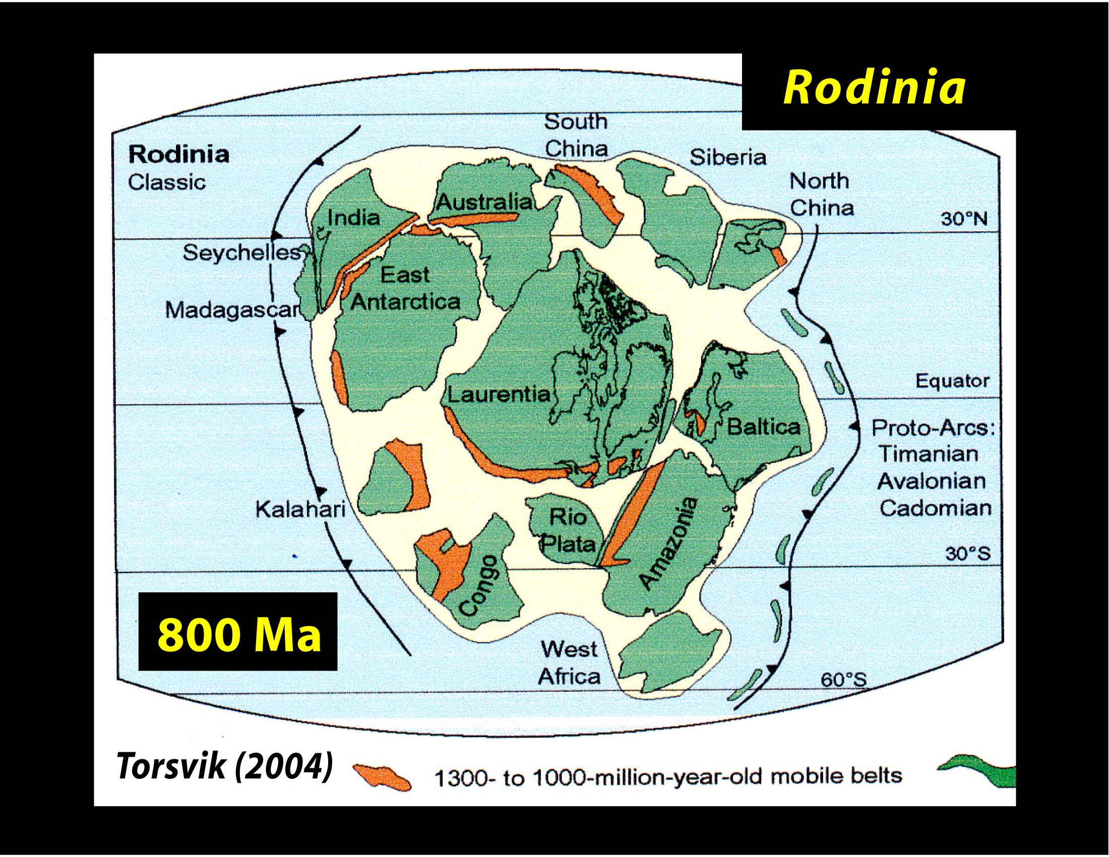
Rodinia 1.1 billion years ago to 750 million years ago. This is the first supercontinent for which we have a consensus of how it fit together. This supercontinent had lots of indentations and marginal seas. Its breakup coincided with the second large scale snowball Earth episode, and the beginning of the evolution of animal life visible to the naked eye. (It is possible that animal life was present earlier--there are fossils of 'worm tracks' which may or may not have been formed by worms over 1 billion years old. These worm tracks could have been produced by non-biological causes. No direct fossil evidence of animal life large enough to see, besides some freakishly big one-cell organisms has been found before the
Ediacaran period.
Some evidence from
molecular clocks indicates that animal phyla separated as long as 1.5 billion years ago. Others say no, much shorter. It is possible that single-cell or near-microscopic eukaryotic animals separated that long ago, and then a common environmental factor stimulated the growth of animals and plants into larger sizes. We just don't know.
A reconstruction of Rodinia:
Pannotia 600 million years ago (briefly by geologic standards) was a strange supercontinent, that by most reconstructions is shaped like a giant 'V'. For reasons not understood the Earth seems to have had a geological freakout. Continents were flying across the map, bouncing off of each other almost like pinballs, old continental structures that had maintained their integrity through the previous cycles of supercontinental formation and breakup were torn apart, and new continental cores were welded together and remained as one. Continents were moving at 12-18" per year, and the pace of continental crust formation, which had been declining for more than a billion years sped up again. Why all this happened is not clear--there is no consensus yet. Pannotia, which formed the quickest after the breakup of the previous supercontinent, seems to have been almost accidental. The continents whizzing across the Earth happened to meet up, stick together a while, and break apart again. Pannotia only lasted 10-15 million years. After this breakup, with all the reshuffling of the continents, old ones breaking apart and new ones put together we see for the first time some continents that correspond with today's continents.
Pannotia had an unusual configuration. Usually with supercontinents there is a large reduction in seashore length and continental shelf area, but Pannotia was V-shaped (or crescent shaped) with all the continents next to each other in an arc. They were connected but not pressed together. This unique configuration preserved lots of shallow continental shelf areas, over wide latitude zones, with a wide variety of rapidly changing environments that stimulated evolutionary development.
Pannotia's appearance:
For about 50 million years after Pannotia broke up, the continents continued whizzing around. Then around 550 million years ago the continents slowed down and the snowball earth freeze/thaw cycle that operated several times between 750 million years ago and 550 million years ago thawed out decisively. It was almost as if the Earth decided that animal and plant lifeforms had developed, now let them grow!
Another mechanism that undoubtedly stimulated animal evolution was higher levels of oxygen. Before Rodinia, oxygen levels had been rising gradually, so gradually. Oxygen was 2%-3% of the atmosphere 2 billion years ago, and 4-5% 800 million years ago. The only difference is that we would aphyxiate more slowly.
But between Rodinia and Pannotia, when the snowball Earth thawed and the oceans turned green, for the first time oxygen climbed above 5%, spiking to 10%-15%. Oxygen fell again when the oceans froze but kept rebounding. When the Earth thawed definitively, oxygen was 12-15% of the atmosphere---enough for the fist time to support large animals. The reason for this was the subduction of large amounts of carbon during the geological freakout. This allowed oxygen to accumulate from being an important constituent of the atmosphere to a major constituent--from then on in second place. CO2 was down to less than 1%, which was good as the Sun continued to warm. There were fluctuations and extinctions, but never again was oxygen scarcity a dominant global condition (although under certain circumstances,
Canfield oceans did form and cause serious problems, such as during the
Permian and
Cretaceous periods)
The concentration of oxygen during prior geologic periods has been been controversial in some respects. During some periods, it appears that there were very high concentrations of oxygen--30% or more. The problem is that is impossible. The intensity of combustion increases by 70% for each 1% that oxygen increases in the atmosphere. In other words, at 22%, an oxygen fire will generate 70% more energy than at 21%. At 25% sopping wet wood will burn, and at 28%-29% wood will spontaneously ignite. The worlds we read of in science fiction stories with bracing, oxygen-rich atmospheres are fiction indeed. The landing of the spacecraft would incinerate the planet!
This can't be emphasized enough---at 30%, just one lighting strike would trigger a forest fire that would rage across continents.
But yet we find fossils of giant insects like this 30" dragonfly:
These giant insects present a big problem--how could they survive in a 21% oxygen atmosphere like today? They can't. They would asphyxiate almost immediately. The solution is that the atmosphere was 1.5 or 2 times as dense as today---lots of oxygen, in a dense atmosphere for giant insects to metabolize, but with the greater amount of atmosphere keeping oxygen concentrations below 23%.
The problem with this idea is what would the additional gas be? It can't be nitrogen. Nitrogen is the only element on Earth found predominantly in the atmosphere. There isn't much in the oceans, there isn't much in minerals or in soil. If we took
all the nitrogen out of the soils and oceans, it would raise nitrogen levels by less that 40%. And nitrogen is needed by life--a big depletion of nitrogen would have reduced life's prevalence drastically in ways not consistent with the fossil record. The giant insects flew in forests full of life. So nitrogen is out.
Carbon dioxide? Nope. Suppose we had an atmosphere of 20% oxygen, 40% nitrogen, and 40% carbon dioxide at double today's pressure. That much CO2 would make it impossible for animals to respire it out of their system. And that is also 2,000 times the amount of CO2 in today's atmosphere. The sun was dimmer, but not that much. By 350 million years ago that much CO2 would send the Earth to the boiling point.
It's hard to see what the mystery gas could be that was added to the atmosphere to dilute oxygen to a non-dangerous level, while keeping oxygen abundant enough for giant insects to thrive.
It has been suggested by some that giant insects could breathe, and had lungs like we do. But there is no fossil evidence for that--the giant dragonflies had
spiracles, just like insects today, and received their oxygen by diffusion. There is still a lot of controversy about this!
Here is a summary of the oxygen concentrations during various geologic periods:
Ediacaran 8% with many spikes up and down, first occurrence of 10%+
Cambrian 12.5%
Ordovician 13.5%
Silurian 14%
Devonian 15%
Carboniferous 32.5% (controversial as noted)
Permian 23%
Triassic 16%
Jurassic 26% (controversial)
Cretaceous 30% (controversial)
Paleogene 26% (controversial)
Neogene 21.5%
Quaternary 21%
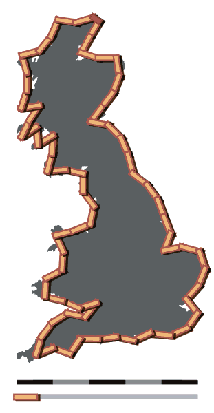
Pangaea formed 250 million years ago and began breaking up 180-100 million years ago. Pangaea is well known so I will just provide an illustration:
We still don't know about the marginal, partly enclosed seas very well before Pannotia. Salt domes don't last very long by geological standards---they fault, let water in, get subducted, uplifted and eroded--we don't have examples of salt domes or extensive evaporite deposits from billions of years ago.
It has been bandied around that Earth was just very lucky---that we happened to have a continental configuration that at all times kept ocean salinity within reasonable bounds. I have read estimates that the chance of random continental configurations keeping salinity within acceptable ranges for our marine life at less than 1%. I have seen others say less than one in a thousand. Others say that unknown processes could have removed salt more efficiently during the time of the Hadean era, when it was much warmer--salty ocean crust could have been buried by massive hot-spot volcanic eruptions before subduction became dominant--could this have been more efficient at removing/burying salt? We don't know.
Could it be that on most earthlike planets, even when life forms, unlucky continental configurations caused lethal changes in ocean salinity and either extinguished life or kept the biosphere very weak, and at a low level, preventing evolution of more advanced forms?
Nobody knows.
But it was the salinity question that was a big priority of oceanographers in the 1930s and 1940s---why isn't the ocean more salty? That question was the big problem for oceanographers---not solving the trivial mystery of the behavior of carbon dioxide interactions between the atmosphere and ocean.